MnDOT issues warning ahead of forecasted heavy rains by NWS-NOAA
![]()
![]()
The Minnesota Department of Transportation (MnDOT) advises travelers to drive with caution in southern Minnesota due to National Weather Service (NWS) forecasted heavy rains on Thursday, June 11.
Officials warn that roads may be closed or restricted without warning as flash flooding is difficult to predict. They also advise motorists to watch for cones and barrels on the roadways as they indicate potential hazards where damage occurred during the recent flooding.
Every flood is dangerous. If you must travel, follow these safe driving practices:
* Check www.511mn.org before traveling for information on road conditions, closures and detour routes.
* Expect the unexpected – flash floods can occur anytime, anywhere.
* Do not drive around barricades or into flooded areas.
* If floodwaters rise around your car, abandon the car and move to higher ground, if you can do so safely.
Six inches of water will reach the bottom of most passenger cars, causing loss of control and possible stalling. A foot of water will float many vehicles. Two feet of rushing water can carry away most vehicles including sport utility vehicles and pick-ups.
When a road is closed it is illegal to travel in that area. Motorists can be fined up to $1,000 and/or 90 days in jail. In addition, if travelers need to be rescued from a closed road, other expenses and penalties will apply.
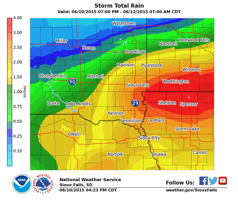
The National Weather Service has predicted heavy rain likely late tonight (Wednesday, June 10) through Thursday night (Thursday, June 11).
Scattered thunderstorms this evening in the Missouri River Valley will move northeast and become widespread across the region overnight. Some of these storms will contain heavy rain. More heavy rain is expected during the daytime hours on Thursday and into some of the night. Rain should move out by late Thursday night.
Not only has this extended period of heavy rains prompted a Flash Flood Watch from 10 p.m. Wednesday night until 7 p.m. Thursday evening, but it is also likely that area rivers will be rising or flooding late this week. Much of southeast South Dakota, southern Minnesota, northern Iowa and northeast Nebraska is expected to receive at least an inch of rain.
At this time the heaviest rainfall is expected to be near and east of Interstate #29 from Elk Point to Flandreau in South Dakota, where many locations may see over 2.50 inches of rain – with local amounts possibly exceeding 3.25 inches in portions of southwest Minnesota and northwest Iowa.
Although this storm system is still coming together tonight, heavy rainfall is likely for parts of South Dakota, Iowa, Minnesota, and Nebraska. While there may be minor changes to the exact placement of the heaviest rainfall, persons within 50 miles north or south of United States Highway #18 across northern Iowa and into southeast South Dakota east of Lake Andes should prepare for the possibility of heavy rain and localized flooding.
A National Weather Service (NWS)-National Oceanic and Atmospheric Administration (NOAA) – Sioux Falls, South Dakota office – map of the latest forecast rainfall amounts is below: